Berg Nephin und Glen Nephin / Nephin and Glen Nephin
Glen Nephin (Suedseite) / Glen Nephin (South Side)
(2015-07-15)
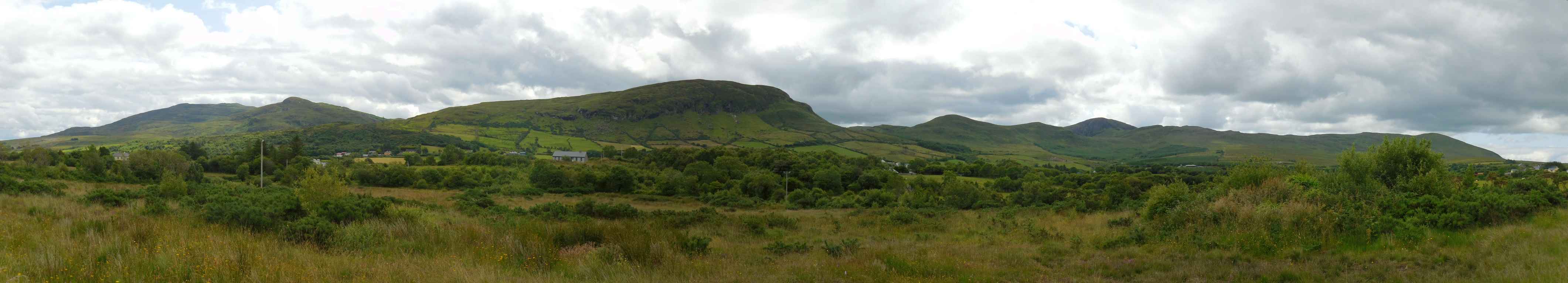
Unten im Tal (in der Ortschaft Curraghmore) werfen wir einen Blick zurück auf den Höhenzug Richtung Süden. Ohne Ortskenntnisse und nur nach der Wanderkarte glaube ich folgende Berge zu erkennen:
Die Gipfel im linken Viertel des Bildes gehören zu dem Berg, dessen höchste Erhebung der Farbreiga (395 Meter) ist. Auf der Wanderkarte sind keine Namen für individuelle Gipfel angeschrieben.
Der Berg in der Mitte mit der Steilwand ist der Crucknaree (297 Meter). Die Straße zum Windy Gap (Windiger Spalt) führt rechts an ihm vorbei.
Die nächsten paar Bergspitzen nach rechts haben auf der Karte keinen Namen. Auffällig ist der Berg Burren (396 Meter) im Hintergrund, der seine Felswand zeigt (auf etwa 1/3 des Bildes von rechts).
Down in the valley (in the village Curraghmore) we cast a view back to the mountain range in the south. Without knowledge of the area and only according to the hiking map I believe to recognizes following mountains:
The peak in the left quarter of the picture belongs to a mountain of which the highest peak is named Farbreiga (395 metres). The hiking map does not give names for individual peaks.
The mountain in the middle with the steep slopes is the Crucknaree (297 metres). The road to the Windy Gap goes by on its right side.
The next few mountain peaks to the right do not have names on the map. The Burren Mountain (396 metres) in the background is eye-catching showing its rock face (about 1/3 from the right border of the picture).
Übersicht über Berg Nephin und Glen Nephin / Overview of Nephin and Glen Nephin
 Glen Nephin (Südseite) / Glen Nephin (South Side)
Zugeordnete Themen / Assigned Topics:
Lage / Location
Irish grid: G 12970 03305


